How to Create Animated Maps in Adobe After Effects
Create dynamic and customizable map animations with the GEOlayers 2 plugin for Adobe After Effects.
A few weeks ago I reviewed Google Earth Studio, a browser-based animation tool which allows users to create videos from Google’s 3D and satellite imagery. The beauty of this program is that it plays well with After Effects, seamlessly exporting 3D camera tracking data. A few minutes of flying your virtual camera around 3D cities and you’ll be hooked.
The unfortunate fact, however, is that Earth Studio is currently for non-commercial use only. Creators are free to use Earth Studio animations in news, research, education, and nonprofit projects, but a commercial license is not yet available. So what could possibly be an alternative to such a powerful map animation tool? Never fear, the GEOlayers 2 plugin is here.
How it Works
GEOlayers 2 lets you browse and animate maps directly inside of Adobe AE via connected imagery tile servers. 14 default Server Profiles are included, each one representing a certain map style. All of the default profiles can be used for free as long as you provide the proper attribution. You can even create and customize your own map styles. Utilize a search tool in the plugin to find countries, cities, borders, rivers, streets, specifics buildings, POIs and much more. Whatever you find can be labeled in your animation, drawn to your map, downloaded, exported and a lot more. Let's take a closer look at what you can do with this powerful plugin.
Label Features
Quickly label features on your map with a simple click. Labels come with an intro animation and a load of customizable attributes. Use and customize the default label templates or create your own from scratch. Any After Effects composition can be used as a label template.
Customize Feature Styles
Create custom style-sets to quickly apply a look to a specific feature. Control options such as color, stroke, fill, opacity and extrusion options. GEOlayers 2 can also automatically apply styles depending on what kind of feature you want to draw.
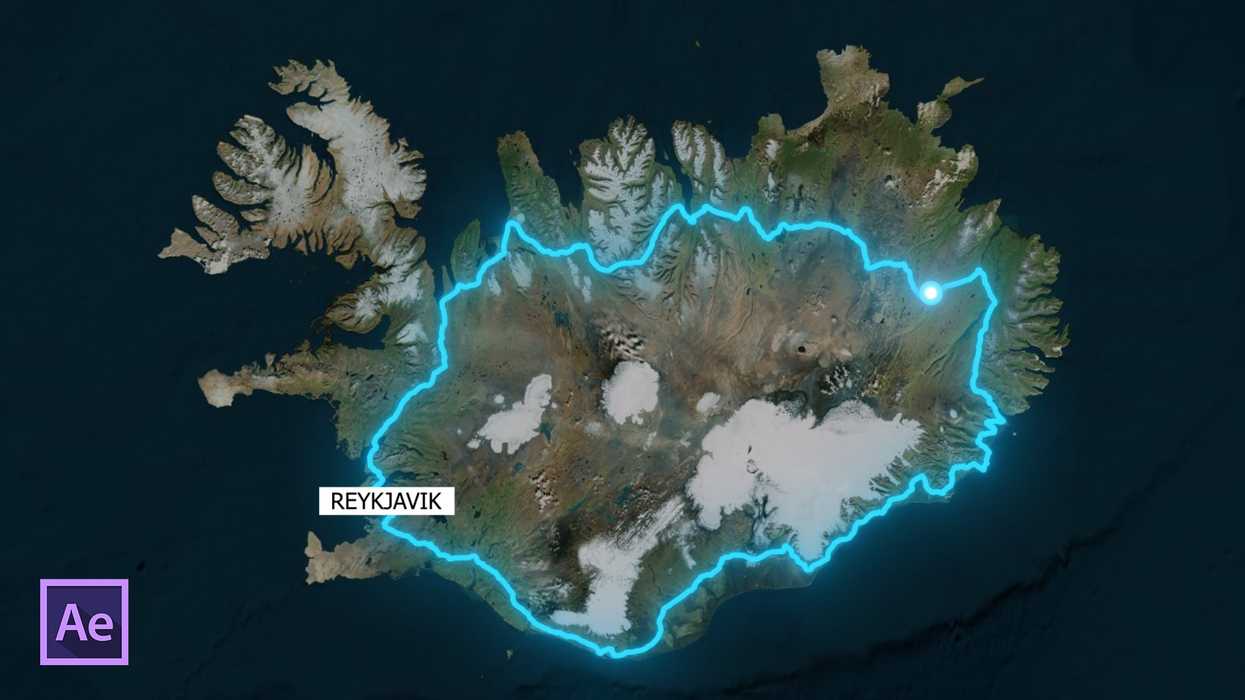
Create a Route
Select two or more locations on a map to create a route via car, bicycle, plane, foot, or via a simple straight line. Snap graphic layers to a route and animate them along the created path.
Visualize Data
GEOlayers 2 allows users to easily import datasets via CSV or TSV files. Data-driven styles help you to beautifully visualize large datasets after only a few clicks.
Extrude Objects
With GEOlayers 2 you can extrude elements such as specific buildings or other graphic elements. Control the amount of extrusion and add lights to give your map more depth.
Create 3D Landscapes (with additional plugins)
If you have Trapcode Mir 2, Mettle FreeForm Pro or Rowbyte Plexus 3 installed you can create 3D Landscape setups with one click. With these tools you can achieve stunning animations based on real data.
The GEOlayers 2 pluging for Adobe After Effects is available for $199.99 here. After Effects CC 2015 (13.6) or higher is required, and legacy projects created with version 1 are not supported by GEOlayers 2.
Want more? Here are 10 After Effects tricks to speed up your workflow, as well as a list of After Effects tutorials.
Disclosure: Boone Loves Video is a participant in affiliate advertising programs designed to provide means for individuals to earn advertising fees by reviewing and linking to products.