We'd love to shoot our next film in Manhattan. But to do that, we would have to spend probably over $1,000 to travel to the City that Never Sleeps in order to scout locations. That's money that could be better spent on the actual shooting itself. But one photographer has come up with a way to scout locations virtually, and for free using Google Earth.
And not only does he get to visit places as if he was standing right there, but he can also adjust the position of the sun in the sky and even adjust a virtual view in order to determine the best focal length for the shot (kinda).
Like most photographers, Tony Northrup has used a combination of PhotoPills and The Photographer's Aphermis. Photo Pills enable you to take an image and see the angle of the sun, including its azimuth. But it won't show you just how the sunlight affects the surrounding buildings or other location elements in real or virtual time. It's just a data point of where the sun will be pointing. The Photographer's Ephemeris does similar calculations and adds a 3d element that will show you just how the sun will fall. Both of these apps cost about $10 each and are available in both the iOS and Google Play Stores.
 Credit: Google
Not a bad price for being a solid tool, but for being able to really visit a sight virtually, and do it for free, Northrup says that nothing beats Google Earth. Formerly known as Google Earth Pro, the app was originally $400 and included a movie maker and data importer. So you could visit a location virtually, and create your own animatic if you wanted. Then Google made the pro version free and it has since become Google Earth for all of us.
"Google has mapped the entire earth in 3D, so you can visit anywhere," Northrup said.
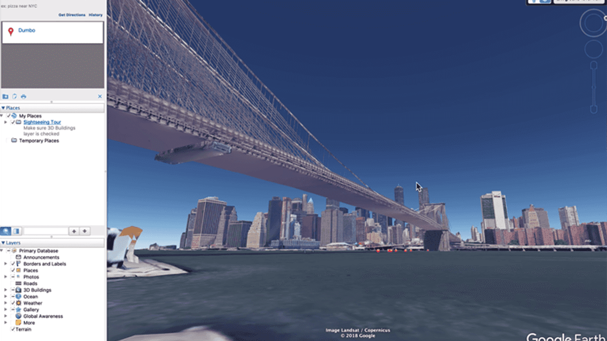
As of 2012, Google managed to capture over 75% all of the land-based geography of our planet, and by now, it's like that figure has approached 95%. Using Google Earth you can visit a location using the "street view" or "ground view" and then move around using the arrow overlays that take you to the next image. For a virtual visit, it really is the next best thing to being there.
The images are created by a combination of satellite imagery, and photos taken from Google's fleet of automated StreetView 360-degree camera cars. And where the cars can't go, Google uses some impressive algorithms to turn the satellite images into 3D builds and shots.
 Credit: Google
But not only can you virtually walk around anywhere in the world, but Google Earth lets you move forward and backward in time and see where the sun will be in the sky. Google Earth also uses a little bit of secret sauce to show how the sun casts a shadow across the sky against buildings, mountains, and how those shadows will affect the light. If you don't like where the sun is on a given day, you can move forward or backward in the calendar and see where the sun will fly across the sky as well. And using the zoom feature, you can zoom in and out (obviously) -- getting a virtual focal length to create screenshots of the image for storyboards or animatics when using the Movie Maker function.
And if your producer suddenly says they can take advantage of tax savings in another state or country, you can virtually travel there and do it all over again. Without spending a dime.
How long before someone makes a movie with virtual backgrounds created by Google Earth? Only time will tell.
Source: Peta Pixel